Digital construction at every touchpoint of the construction lifecycle
From initial design validation to post-construction quality assurance and dispute resolution, using a digital construction analytics platform has benefits across the civil constructionCivil construction is a branch of engineering that involves the design, construction, and maintenance of the built envir... More project lifecycle.
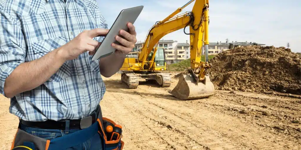
By integrating digital technologies such as photogrammetryPhotogrammetry is the science of obtaining accurate measurements and three-dimensional information from photographs. It ... More and drone mapping software with advanced data analytics and digital constructionDigital construction, also known as construction technology or construction 4.0, refers to the use of digital tools and ... More management, stakeholders across the value chain can better manage their construction projects. They can optimize the quality and safety of projects, reduce resource investment, and improve productivity.
Here’s how we see it in practice at DatuBIM, through different stages of the construction project lifecycle.
Streamlining pre-construction through design validation and planning
Prior to actually setting foot on a construction site, a digital construction platformDigital construction platforms are used to streamline and optimize construction processes using digital technology. They... More can support businesses with their vision and roadmap. Using aerial mappingThe term aerial mapping refers to a technique that captures photographs and measurements from above using unmanned drone... More technology, drone flights take as many images as necessary, which are then uploaded to a single centralized platform and processed to a survey-grade accuracy, digital terrain model. These serve as a pre-construction baseline, and are augmented with intelligent analytics and predictive intelligence to understand exactly what teams are working with, and to answer questions that may arise ahead of time. For example:
- In a highly-populated residential area, how will you minimize disruption?
- What utilities are there to consider and how will these impact the roadmap?
- What excess materials will there be from clearing a specific area?
If deviations from existing design plans exist, this can be quickly identified and communicated to the owners. Being able to reconcile plans with actual site conditions ahead of time reduces the risk of costly rework and improves communication between varied stakeholders from day one.
Adding accurate estimations at the bidding stage
Bidding is a sensitive process. You don’t want to bid too high, and lose the opportunity to a competitor, but at the same time, if you bid too low — you could end up agreeing to work that’s not profitable. One of the major problems is that construction teams are often basing their bids on outdated survey information or maps.
With a photogrammetry solution, teams can take as many real-time pictures as they need until they know exactly what they are dealing with. In some cases, the project will be easier than it appeared on publicly available records, allowing you to bid less and undercut the competition. However even if this isn’t the case, you can feel confident that you’re able to bid accurately, ensuring that if and when you win the bid — you won’t be left out of pocket.
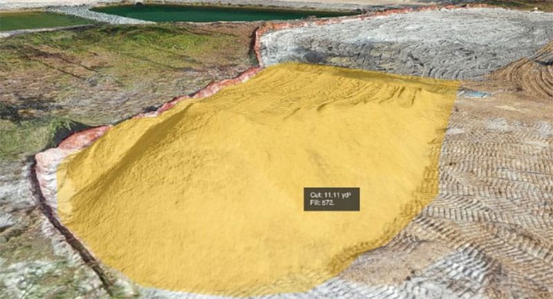
The 4D survey-grade mapping from pre-bid drone flights can also be a major competitive edge when throwing your hat in the ring, both for construction, and also for companies evaluating specific land prior to development. Pre-development, it gives companies an invaluable vantage point before they move forward, and when bidding on construction, owners that see that you have already surveyed and mapped the area, and processed that data ahead of time, recognize that you have the technology in place to retain visibility and control throughout the length of construction. This technology allows you to add crucial information to your calculations, such as stockpile measurementsStockpile measurements in the realm of construction or earthworks pertain to the systematic process of quantifying and a... More for analyzing the amount of dirt that needs to be removed and filled.
Offering remote management and monitoring during construction
As a project begins, a digital construction platformDigital construction platforms are used to streamline and optimize construction processes using digital technology. They... More can be utilized to track and monitor project progress in granular detail. Instead of sending teams out to worksites multiple times a week to carry out foot topos of the terrain, project managers can send a drone pilot, and simply process the information from the office in a matter of minutes. We’ve seen customers save 50% of the time they previously spent traveling to sites and making manual progress checks.
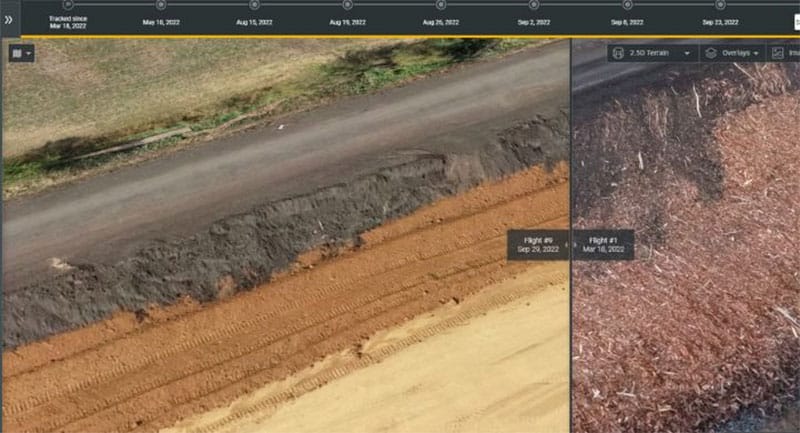
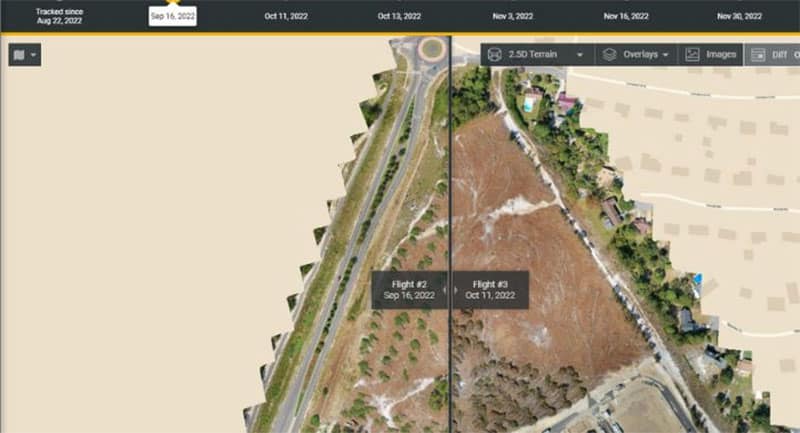
The technology can also be used to take regular imaging to ascertain progress and quality of work. Managers can track objects that may result in change orders, perform quality control over the work completed by subcontractors, identify unexpected deviations from design at the earliest possible stage, and use visual progress tracking to easily compare differences between various dates with the help of digital twins of your site. This is critical for streamlined and accurate collaboration, and the data and associated reports can be easily shared during status meetings and when offering updates across teams.
Regular project tracking via aerial mappingThe term aerial mapping refers to a technique that captures photographs and measurements from above using unmanned drone... More gives a project manager much greater insight and control over any project. The more information they have to make decisions, the better those decisions will be, especially when augmented with predictive intelligence. This enhanced quality assurance is a powerful value add and allows teams to find and resolve potential deviations or clashes before they become a more expensive or costly problem to handle.
Ensuring zero mistakes in billing and invoice validation
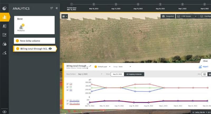
As custom supervision reports can be created directly from a digital construction platformDigital construction platforms are used to streamline and optimize construction processes using digital technology. They... More, businesses can validate the accuracy of all subcontractor invoices, for example examining earthwork bills automatically against the work completed on site.
Without the need for costly and time-consuming manual surveying in the field, project managers can receive up-to-date quantity reporting and measurement analytics — zooming into the most granular details. If for example, additional tasks need to be billed for, a digital construction platformDigital construction platforms are used to streamline and optimize construction processes using digital technology. They... More can fill the gaps, providing the data to back up any line item.
Consider a situation where the ground is wet and the amount of earthwork is tough to estimate ahead of time. When a certain pre-bid cap has been reached, accurate measurements can be taken ahead of charging for additional materials.
In short, your team is always fairly compensated for the work they have done.
Supporting better dispute resolution during and post-construction
A construction site is a complex place, and it’s natural for disputes to arise, both during construction and once a project is complete. When this happens, you want the project visibility and the single source of truth to know exactly what your next steps should be.
We’ve seen customers use DatuBIM as a digital diary, with access to drone footage and analytics across every stage of the project, which can serve as valuable evidence where necessary. This reduces “on hold” time during construction, where projects are stuck and unable to progress due to a disagreement, and takes the tension out of post-construction disputes, too.
Without a centralized source of truth, teams can often rely on disparate communication streams, leaning on Excel spreadsheets, email threads, and even WhatsApp messages as critical sources of information. Site workers can be asked to hold valuable details in their heads for hours before they get back to the office or their computers to write it down. If and when a dispute occurs, this data is difficult to verify or rely on. In contrast, with the right digital constructionDigital construction, also known as construction technology or construction 4.0, refers to the use of digital tools and ... More software, everything you need to know is in one place, automatically gathered and organized, and with no doubt as to its accuracy.
A digital construction platform is your competitive edge
According to McKinsey Research, “Other industries have shown that first movers [in technology] can build a sustainable competitive advantage. In the construction sector, this is also likely to be the case. Over the next decade, these winners of tomorrow will take the lead in technology innovation and digitization.”


