As the field of photogrammetryPhotogrammetry is the science of obtaining accurate measurements and three-dimensional information from photographs. It … More continues to evolve, technology now plays a pivotal role in various stages of business operations, including design, validation, billing, and dispute resolution. This guide highlights the leading photogrammetry softwarePhotogrammetry software is a type of computer software that is used to create 3D models of objects and environments usin… More of 2023, detailing their strengths and potential limitations, with a special focus on their application in heavy civil and infrastructure constructionInfrastructure construction refers to the process of designing, planning, and building physical structures and facilitie… More.
DatuBIM: A Leader in Heavy Civil and Infrastructure ConstructionInfrastructure construction refers to the process of designing, planning, and building physical structures and facilitie… More
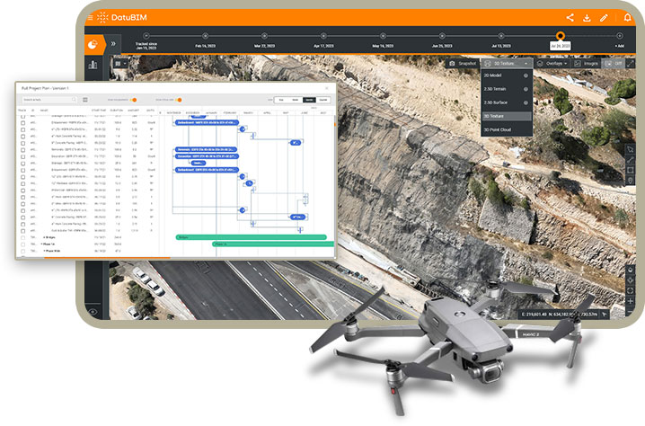
DatuBIM is the premier cloud-native SaaS platform uniquely dedicated to heavy civil and infrastructure constructionInfrastructure construction refers to the process of designing, planning, and building physical structures and facilitie… More. Unlike other photogrammetry softwarePhotogrammetry software is a type of computer software that is used to create 3D models of objects and environments usin… More, DatuBIM is designed with the specific challenges of large-scale construction projects in mind. It utilizes AI and drone mappingDrone mapping is the process of creating maps and 3D models of geographic areas using images and data captured by drones… More technology to convert aerial data into precise 3D models and maps, offering unparalleled insights into project progress and analytics.
While other platforms like Propeller, Pix4D Cloud and Drone Deploy offer versatile solutions applicable across various sectors, none zeroes in on the heavy civil and infrastructure sector with the same focus as DatuBIM. This singular dedication enables DatuBIM to provide features and tools that are finely tuned to support the complexities and scale of infrastructure projects, ensuring more accurate planning, monitoring, and execution.
Comparative Overview of Other Photogrammetry SoftwarePhotogrammetry software is a type of computer software that is used to create 3D models of objects and environments usin… More
- Correlator3D by SimActive caters to various verticals, including mining and forestry, demonstrating flexibility but not a targeted approach to heavy civil constructionCivil construction is a branch of engineering that involves the design, construction, and maintenance of the built envir… More.
- Propeller consolidates photogrammetric production tools for general project management, but it lacks the specialized focus on the heavy civil sector and is harder to use than DatuBIM.
- Pix4Dmapper transforms images into detailed point clouds and maps, serving a wide audience without specifically addressing the unique needs of heavy civil constructionCivil construction is a branch of engineering that involves the design, construction, and maintenance of the built envir… More.
- DroneDeploy and RealityCapture each bring valuable tools to the photogrammetryPhotogrammetry is the science of obtaining accurate measurements and three-dimensional information from photographs. It … More domain, yet they do not emphasize heavy civil and infrastructure constructionInfrastructure construction refers to the process of designing, planning, and building physical structures and facilitie… More as their primary focus.
DatuBIM stands out by providing real-time comparisons against design briefs, facilitating in-depth analytics on progress, and enhancing collaboration across all stages of a construction project. This focus ensures stakeholders can prevent costly reworks and maintain transparency, particularly in the heavy civil and infrastructure sectors.
By enabling accurate measurement of distances, areas, volumes, and earthworksEarthworks are an essential part of modern infrastructure and are used in a variety of industries including construction… More directly from the data collected by drones, DatuBIM offers a level of precision and efficiency unmatched by platforms with a broader focus. Its capabilities are not just about data collection but about providing a comprehensive, accurate view of large-scale infrastructure projects, making it an indispensable tool for owners and project managers dedicated to these sectors.
Choosing the Right Photogrammetry SoftwarePhotogrammetry software is a type of computer software that is used to create 3D models of objects and environments usin… More
Selecting the appropriate photogrammetry softwarePhotogrammetry software is a type of computer software that is used to create 3D models of objects and environments usin… More hinges on understanding your project’s specific needs. For those in heavy civil and infrastructure constructionInfrastructure construction refers to the process of designing, planning, and building physical structures and facilitie… More, DatuBIM represents a strategic partnership that aligns with the nuanced requirements of large-scale projects. Its dedicated focus on this sector means that DatuBIM is a tool and a partner equipped to navigate the challenges and complexities unique to heavy civil and infrastructure constructionInfrastructure construction refers to the process of designing, planning, and building physical structures and facilitie… More.
In contrast, while other photogrammetryPhotogrammetry is the science of obtaining accurate measurements and three-dimensional information from photographs. It … More platforms offer valuable features for various applications, they lack DatuBIM’s specialized approach. DatuBIM is the go-to choice for professionals prioritizing precision, efficiency, and tailored solutions in their construction projects.
At Datumate, we’re committed to empowering our customers with the technology and support needed to excel in the demanding arena of heavy civil and infrastructure constructionInfrastructure construction refers to the process of designing, planning, and building physical structures and facilitie… More. Discover how DatuBIM can transform your approach to construction projects by scheduling a demo with our team today.


