Drone photogrammetryDrone photogrammetry is the process of using unmanned aerial vehicles (UAVs or drones) to capture aerial photographs of … More uses drones to capture many 2D images over a specific geographic area. These images are then uploaded to a platform where accurate 3D or even 4D terrain models, digital twins, and orthomosaic maps are created, using photogrammetryPhotogrammetry is the science of obtaining accurate measurements and three-dimensional information from photographs. It … More engine.
PhotogrammetryPhotogrammetry is the science of obtaining accurate measurements and three-dimensional information from photographs. It … More drone software has come a long way over the past few years. From initial design validation to post-construction dispute resolution, a digital constructionDigital construction, also known as construction technology or construction 4.0, refers to the use of digital tools and … Moreconstruction analyticsConstruction analytics is the application of data analytics and business intelligence techniques to the construction ind… More platform that utilizes drone photogrammetryDrone photogrammetry is the process of using unmanned aerial vehicles (UAVs or drones) to capture aerial photographs of … More provides benefits across the construction lifecycle. Keep reading to learn everything you need to know!
What is drone photogrammetry?
Drone photogrammetryDrone photogrammetry is the process of using unmanned aerial vehicles (UAVs or drones) to capture aerial photographs of … More uses drones to collect many images of a targeted geographic area. Physical information is then collected from these two-dimensional images, which, with the right software in place, can then be transformed into accurate three-dimensional models and maps and complete digital twins of any terrain.
How does drone photogrammetry work?
To create accurate 3D models, drones take a lot of images. Multiple views of the same terrain elements are critical to piecing together a clear and complete 3D or 4D model. A photogrammetryPhotogrammetry is the science of obtaining accurate measurements and three-dimensional information from photographs. It … More drone must fly at the right altitude, catch every angle, and perform its flight consistently and steadily, or images may be unusable. As a result, a drone might take hundreds or even thousands of images on a single flight to get the right images and ensure they have enough image overlap.
There are two distinct stages in drone photogrammetryDrone photogrammetry is the process of using unmanned aerial vehicles (UAVs or drones) to capture aerial photographs of … More. First is the image capture, which is the point of data collection. Next, the image processing.
How accurate is drone photogrammetry?
One of the benefits of using aerial photogrammetryPhotogrammetry is the science of obtaining accurate measurements and three-dimensional information from photographs. It … More and drone mappingDrone mapping is the process of creating maps and 3D models of geographic areas using images and data captured by drones… More is improved accuracy overtaking manual photos. Drones can fly in areas that are otherwise unsuitable or inaccessible, which allows 3D models to be created with photogrammetryPhotogrammetry is the science of obtaining accurate measurements and three-dimensional information from photographs. It … More data that have a high level of accuracy down to the cm level.
Of course, accuracy may vary depending on a number of factors. Your photogrammetryPhotogrammetry is the science of obtaining accurate measurements and three-dimensional information from photographs. It … More mission should aim to correct or strategize against issues such as too few photos, a poor photo overlap ratio, incorrect altitude, or poor GPS signal strength. For example, during mission planning, you could discuss the need for RTK or PPK, GPS correction technologies that can complement Ground Control Points and add accuracy to a complex flight path. Later in this guide, there are more tips for improving accuracy in drone flights and data processing.
Real-world use cases for drone photogrammetryDrone photogrammetry is the process of using unmanned aerial vehicles (UAVs or drones) to capture aerial photographs of … More in construction
When thinking about complex construction and civil engineering projects, drone mappingDrone mapping is the process of creating maps and 3D models of geographic areas using images and data captured by drones… More and modeling can move the needle in a number of important areas. Let’s dive into five of the most important.
1. Design validation and planning
Use drone photogrammetryDrone photogrammetry is the process of using unmanned aerial vehicles (UAVs or drones) to capture aerial photographs of … More to set your pre-construction baseline, so that you know exactly what you’ll be working with ahead of time. You can identify any deviations from existing design plans, communicate this to the owners, and reduce the risk of rework — which is one of the costliest areas of any construction project. This visibility also helps you to spot areas that may cause you problems ahead of time, such as utilities or excess materials.
2. Accurate bidding for a project
Instead of basing your initial bid on someone else’s drone data or on outdated survey information, drone photogrammetryDrone photogrammetry is the process of using unmanned aerial vehicles (UAVs or drones) to capture aerial photographs of … Morephotogrammetry softwarePhotogrammetry software is a type of computer software that is used to create 3D models of objects and environments usin… More can give you a truly accurate and real-time view. This allows you to bid fairly, so that you don’t end up with an unprofitable project, or being undercut by a competitor with more information about the site. Drone photos may help you see that the project is actually easier than it appears on records available to the public, or can help you stay two steps ahead so you don’t end up biting off more than you can chew.
Psst: Owners are generally impressed by any bidder with access to the technology necessary to keep visibility and control throughout a project and put it into action as early as the bidding stage.
3. Remote monitoring
It can be expensive to send teams out to view and manage a physical site multiple times a week. With drone mapping softwareDrone mapping software is a type of software that is used to create accurate maps and 3D models from data collected by d… More and a photogrammetryPhotogrammetry is the science of obtaining accurate measurements and three-dimensional information from photographs. It … More solution, this can be done remotely, processing the information at the point cloud images appear on-screen only a few hours after photos are taken. This can save serious time and resources over manual progress checks. Regular images by drone allow managers to check on progress, measure earthworksEarthworks are an essential part of modern infrastructure and are used in a variety of industries including construction… More, understand the workers’ quality, and stay two steps ahead of any deviations in design at the earliest stage. As all images are stored on the platform, smart construction management softwareConstruction management software is a specialized software designed to help stakeholders involved in construction projec… More allows teams to compare the difference between the current site against any historical baseline, identifying progress from one date to another.
4. Safety and security on-site
Injuries on construction sites are not uncommon. In fact, nearly 1 in 5 workplace deaths happen in the construction industry, with a third of these related to falls, slips, and trips. It’s your responsibility as a business to ensure you complete thorough risk assessments and support your teams by reducing the risk as much as possible. Drone mappingDrone mapping is the process of creating maps and 3D models of geographic areas using images and data captured by drones… More is critical to uncover issues ahead of time, such as unstable surfaces or hazards that may make a construction site less safe. There are often difficult-to-reach areas in a construction project, and the ability to remotely map these hard-to-access areas and identify potential safety issues on an ongoing basis is invaluable. Drone mappingDrone mapping is the process of creating maps and 3D models of geographic areas using images and data captured by drones… More can also help with security by tracking assets, including machines and materials.
5. Dispute resolution
The final benefit we will discuss here is providing a single source of truth in case a conflict arises during or after construction. As your photogrammetry softwarePhotogrammetry software is a type of computer software that is used to create 3D models of objects and environments usin… More solution provides drone footage and analytics over time, it’s like a digital diary of the whole project in many ways. You can turn to the images at specific dates to see what earthworksEarthworks are an essential part of modern infrastructure and are used in a variety of industries including construction… More were completed, when specific tasks were done, and any evidence you need to resolve the dispute. Instead of collecting various messages from communication apps, emails, Excel spreadsheets, and “he said, she said”, you have a verifiable and unarguable single pane of glass.
How is resolution defined in photogrammetry?
Drones collect high-resolution aerial data, but what do we mean by resolution? Mostly, you will need to think about spatial resolution. This refers to how much detail you get from each image that is taken on a drone flight. This is also known as pixel size or ground sampling distance (GSD)Ground Sampling Distance (GSD) is a term used in remote sensing and photogrammetry that refers to the size of the smalle… More distance.
In a digital image taken for drone mappingDrone mapping is the process of creating maps and 3D models of geographic areas using images and data captured by drones… More of a geographic area, for example, for construction use cases, each pixel will equate to a part of the land, and the spatial resolution is usually measured in cm per pixel. That’s how much land is covered by each pixel or square of the image. The lower you fly, the higher the spatial resolution can be. However, you do need to remember that this means it will take longer to cover a whole area, especially as drones will need to fly more slowly to ensure they keep focus and consistency, so it’s a bit of a balancing act.
What is LiDAR and how does it work?
LiDARLidar (Light Detection and Ranging) is a remote sensing technology that uses laser light to measure distances and create… More stands for Light Detection and Ranging, and it’s a remote sensing technology that uses lasers to measure distance. Drone mappingDrone mapping is the process of creating maps and 3D models of geographic areas using images and data captured by drones… More is often augmented with LiDARLidar (Light Detection and Ranging) is a remote sensing technology that uses laser light to measure distances and create… More technology, where light pulses are sent out, and the time it takes for the reflection to return is measured. An accurate digital model can be built by measuring the distance between the sensor and the ground elevation.
With LiDARLidar (Light Detection and Ranging) is a remote sensing technology that uses laser light to measure distances and create… More, teams can create more accurate 3D representations of objects and terrains in any geographical area. It can support teams with planning, design, and quality control, monitoring progress, and providing accurate visualizations.
Photogrammetry vs. LiDAR: which is better?
Both drone photogrammetryDrone photogrammetry is the process of using unmanned aerial vehicles (UAVs or drones) to capture aerial photographs of … More and LiDARLidar (Light Detection and Ranging) is a remote sensing technology that uses laser light to measure distances and create… More are powerful solutions for aerial mappingThe term aerial mapping refers to a technique that captures photographs and measurements from above using unmanned drone… More and surveying. However, a few differences can help you make the right decision for your use case.
First up, the cost of the solution. PhotogrammetryPhotogrammetry is the science of obtaining accurate measurements and three-dimensional information from photographs. It … More is usually more cost-effective, as the LiDARLidar (Light Detection and Ranging) is a remote sensing technology that uses laser light to measure distances and create… More equipment is more expensive as a baseline cost. As photogrammetryPhotogrammetry is the science of obtaining accurate measurements and three-dimensional information from photographs. It … More has been proven to be just as accurate in most situations, this may be the end of the conversation for you.
However, in certain contexts, LiDARLidar (Light Detection and Ranging) is a remote sensing technology that uses laser light to measure distances and create… More might be the right choice, as it provides a high level of vertical accuracy — especially important in a densely vegetated area. If you’re looking for highly accurate data on a ground surface with dense foliage, for example, in forestry management and control, LiDARLidar (Light Detection and Ranging) is a remote sensing technology that uses laser light to measure distances and create… More may be the right fit.
LiDARLidar (Light Detection and Ranging) is a remote sensing technology that uses laser light to measure distances and create… More is also a good option for a dark environment, where there is no light at all, or very low light. The technology works with pulses of light to perform surveys and maps at night or when there is heavy cloud cover, for example.
Remember, LiDARLidar (Light Detection and Ranging) is a remote sensing technology that uses laser light to measure distances and create… More cannot capture RGB colors or texture characteristics of any survey area, which can impact the visual quality of your digital terrain. If this is critical to you, look for a LiDARLidar (Light Detection and Ranging) is a remote sensing technology that uses laser light to measure distances and create… More drone that includes RGB sensors as an extra — which will add to the cost but sidestep the issue.
Tips for improving accuracy in drone photogrammetry
Whichever solution you’re using, accuracy is your North Star. To ensure that you get the most accurate digital model of your real-world terrain, here are a few top tips:
- Ensure you utilize GCPs: Ground Control Points are an important survey element. These are physical markers such as orange Xs spray painted on the ground at fixed coordinates or a distinct pattern of white and black rings, for example. As these have a set coordinate, they can be used to improve the accuracy of your photogrammetryPhotogrammetry is the science of obtaining accurate measurements and three-dimensional information from photographs. It … More. Ensure your camera is set to save the geo-location of the images, as it is usually not possible to process images that do not have geo-tagging information.
- Adjust camera settings: Exposure and image quality must be consistent throughout a drone flight, or accuracy will suffer. Adjust all the settings manually to ensure they remain standardized instead of relying on automatic exposure. The same applies to flight altitude and speed — it should be consistent throughout.
- Take enough images: The more images, the better — really! Overlapping images is crucial for accuracy, and you should aim for about 80% overlap of images and consider side-laps, which can support more accurate stitching together of imagery. If the weather or coverage is poor, either reschedule the flight or make sure to take more images than you think you need. Remember, LiDAR-based solutions can help you when dense vegetation is causing issues or if light levels are poor.
- Use advanced surveying techniques: For survey-grade accuracy, you need survey-grade tools. This could be Total Stations, GPS technologies, laser scanningLaser scanning is a technology used to capture and create highly-detailed and accurate digital representations of physic… More, and more. Analytics engines are also a must-have, or you won’t know what you’re looking at or the right questions to ask. In short, without the right technology in place, it’s hard to obtain precise and reliable data — you’re only as good as the software and technology you have at your disposal.
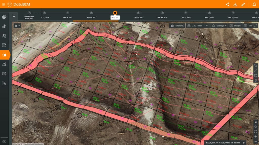
DatuBIM is a powerful digital construction platform for drone photogrammetry
At Datumate, drone mappingDrone mapping is the process of creating maps and 3D models of geographic areas using images and data captured by drones… More and photogrammetryPhotogrammetry is the science of obtaining accurate measurements and three-dimensional information from photographs. It … More are our bread and butter. DatuBIM is a single construction data analyticsConstruction data analytics involves using data to gain insights and make informed decisions related to construction pro… More and management platform that uses drone and laser scanningLaser scanning is a technology used to capture and create highly-detailed and accurate digital representations of physic… More mapping and an advanced AI and photogrammetryPhotogrammetry is the science of obtaining accurate measurements and three-dimensional information from photographs. It … More engine to provide full visibility and control into all infrastructure and transportation projects.
We’ve seen customers realize 50% time savings in the field, improve collaboration by 70%, and achieve 60% better accuracy in their estimations by leveraging our cloud-based software solution.
While manual data collection slows decision making, automating the collection, processing and analyzing of survey-grade data takes your business to the next level. DatuBIM provides greater detail and insight into your projects, accurate visualization into large, inaccessible, or dangerous topography, and a more cost-effective solution than large teams physically traveling to the construction site to stay on top of progress.
Sounds interesting? Let’s schedule a time to discuss how a photogrammetryPhotogrammetry is the science of obtaining accurate measurements and three-dimensional information from photographs. It … More and drone mapping softwareDrone mapping software is a type of software that is used to create accurate maps and 3D models from data collected by d… More solution with data analytics could make all the difference to your next bid.


