DatuBIM
Cloud-native SaaS platform for 4D infrastructure construction data analytics
Digitize and automate your infrastructure construction projects and complete high-quality roads, highways and railways – on time and within budget.
Powering decision-making for complex infrastructure and civil construction across the project lifecycle


Deliver high-quality projects – on time and within budget!
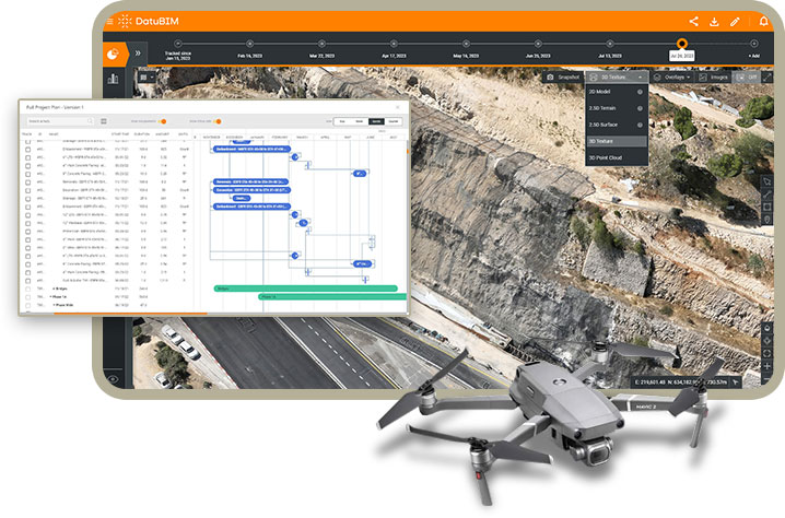
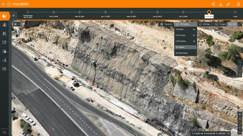
DatuBIM is an automatic, cloud-native SaaS construction data analyticsConstruction data analytics involves using data to gain insights and make informed decisions related to construction pro… More and management platform based on an AI and photogrammetric drone mappingDrone mapping is the process of creating maps and 3D models of geographic areas using images and data captured by drones… More engine. This collaborative platform turns your drone and laser scanningLaser scanning is a technology used to capture and create highly-detailed and accurate digital representations of physic… More data and images into survey-grade 3D models and maps.
These accurate replicas of your site, when combined with detailed engineering and progress reports, allow for ongoing comparisons against designs and previous as-builts. Furthermore, the platform provides in-depth analytics and insights. As a result, you can enhance transparency and collaboration among all stakeholders, make well-informed decisions based on concrete facts, and more effectively manage and monitor project progress from any location.
Turn your drone and laser scanning data into analytics and insights
Leverage the power of AI to digitize your construction site
Track work progress, detect deviations and prevent rework
Enhance collaboration, reduce uncertainty and improve efficiency
Do more with the same resources in less time
Your single source of truth across the entire project lifecycle
DatuBIM is integrated into every phase of your project to automate and optimize processes. Digitized project execution provides you with a single source of permanently updated data and insights throughout the entire project life cycle.
01
Automatic, frequent capture and upload of drone images and laser scanningLaser scanning is a technology used to capture and create highly-detailed and accurate digital representations of physic… More data.
02
Following the initial setup of physical GCPs, a unique algorithm creates virtual ground control points that are used from this point on.
03
Automatic generation of survey-grade models and maps from ground and/or aerial images.
04
Data analytics, insights, geo-referenced annotations, and sharing of information with all stakeholders.
05
State and progress reports including comparisons against design and as-builts from all project phases.
Seamless integration with existing workflows and systems
- DatuBIM seamlessly supports a wide range of file formats, including DXF, LAS, TIF, DWG, XML, DGN, IFC, enabling smooth data integration with your existing workflows
- Avoid disruption to your established processes as DatuBIM ensures compatibility with both global and local coordinate systems, supporting your specific project requirements
Data that matters right at your fingertips
Ongoing data and analytics
- Access accurate engineering data and process analytics for hands-on project management
- Generate state and progress reports with the click of a button
Multiple models and outputs
- True orthophotos - survey-grade precision and accuracy, georeferenced to user-defined coordinate systems
- 3D texture mesh models
- 3D point clouds
- 2.5D elevation maps and contours – Digital Terrain Model (DTM) and Digital Surface Model (DSM)
Visualization and progress monitoring
- Compare Design vs. Pre-Construction vs. As-Built
- Easily track execution progress over time by comparing digital twins of your construction site from different dates
- Stay on schedule by monitoring execution progress and comparing work executed with design plans
Annotations for easy collaboration
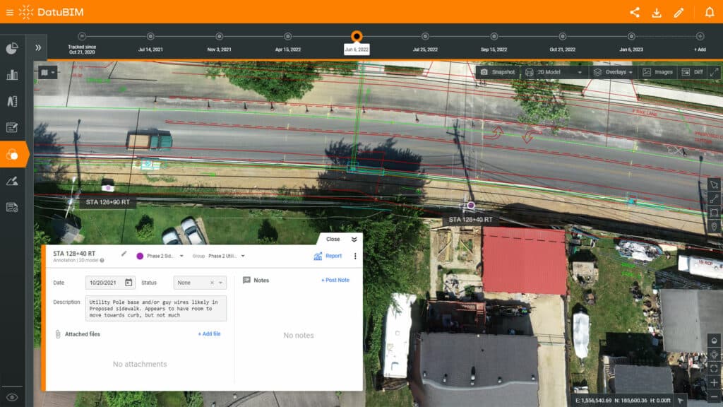
- Easily collaborate with other stakeholders by adding annotations (notes) about anything that is georeferenced in the real word
- Annotate on all image and file types
- Assign annotations to specific users
- Notify users about changes and status updates
Measurements and volumes
- Accurately measure distances, areas, volumes elevations, and cut/fill amounts
- Keep track of progress KPIs, costs, and completeness according to design
- Share information with other stakeholders for full transparency and accurate billing verification
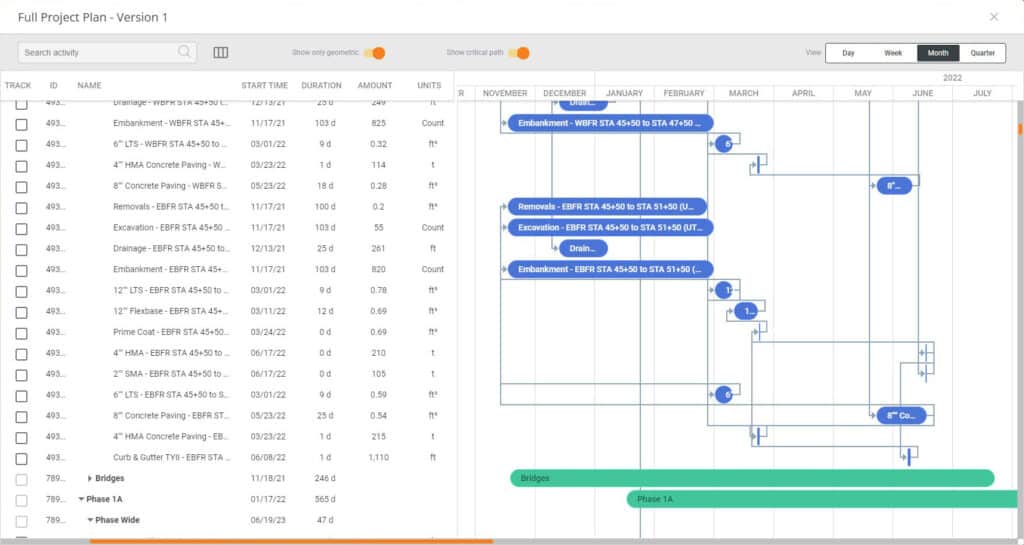
4D mapping and schedule tracking
- Use advanced 4D capabilities to integrate with project scheduling tools
- Easily monitor, track, update and report on task progress according to actual work done in the field
Reporting and documentation
- Streamline data collection from the field
- Automatically generate reports and digital project documentation
- Easily share reports and keep all stakeholders informed throughout the project lifecycle
Supervision and quality control
- Enhance your quality assurance, inspection, and supervision processes
- Utilize high-resolution drone imagery for improved site monitoring
- Strengthen your construction site's overall quality control measures
- Ensure accurate and detailed oversight of your project's progress